Tuesday, June 09, 2015

May 2015 Lake Levels,Discharge, and Osage River Levels


Despite all of the rain, May finished just below full pool, but a foot above the five year average for this time of year, as indicated by the dotted orange line.  As we can see by the green discharge rates peaking at licensed maximum of 35,000cfs, Ameren has been generating a lot of electricity. Discharge rates nearly maximum around the clock have a significant impact on the Osage River levels below Bagnell Dam, as can be seen by the chart below for the same period of time.


Notice that these swings in level starting on the 12th are almost 10 feet and remain high into June.

Friday, May 29, 2015

1902 - Confluence of the Osage and Niangua River

This is an amazing pre-Bagnell Dam picture of the joining of two major rivers, the Osage and Niangua, from 1902.  These rivers now feed the Lake of the Ozarks and in 30 years time from this photo, this farm and land will be underwater.

The State Historical Society of Missouri, Photograph Collection


Wednesday, May 27, 2015

Bull Shoals Striped Bass Sets Missouri Record

Photo Courtesy of the Missouri Department of Conservation
Bull Shoals Lake is located largely in northern Arkansas but has a sizeable portion in Missouri. It is a very popular lake due to it's pristine environment, excellent bass fishing, and cold, clear water.

This striped bass is a new Missouri record for a "pole and line" catch, which presumes it was caught on the Missouri side of the lake. The bass officially weighed in at 65lbs 2oz, beating the previous record by almost 5lbs.  At nearly 50" long, this is a true river monster. Lawrence Dillman of Rockaway Beach, near Branson Missouri, gets bragging rights for this one.  On May 21st, he fought 45 minutes to haul this fish to the bank, caught on minnow bait using a reel with only 20-lb test line. That took some skill.

I can only imagine hooking into one of these while in a kayak.  That would be a ride.

MDC article

Wednesday, May 20, 2015

The Summer Season Begins - Let's Play Safe!

As Memorial Weekend approaches I've taken the time to update the page "How Safe Is the Lake of the Ozarks" to reflect the recently released U.S. Coast Guard report for 2014, and while nationally there was a small increase in fatalities across the U.S., and an actual drop in fatal accidents statewide in Missouri, an analysis of data from the Missouri State Water Patrol shows a startling increase in fatalities at the Lake of the Ozarks last year.

The fatality rate* for the Lake of the Ozarks has soared from 5.6 in 2013 to a nauseating 18.0 for 2014.  Nationally, for 2014, the number of registered vessels in the U.S. dropped by nearly 210,000 boats (a trend that has been happening for many years), while the total number of deaths stayed virtually the same. The effect of fewer vessels was to increase the national fatality rate to an average of 5.2, up from 4.7 in 2013.

Statewide, Missouri fatal accidents dropped from 16 in 2013, to 13 in 2014, but sadly Lake of the Ozarks contributed 9 of those 13, including a highly publicized incident involving Water Patrol when an incarcerated passenger fell overboard and drowned.  [On a personal note, as a Coast Guard veteran who spent three of my four years on ships involved in maritime law enforcement, search and rescue, and aids to navigation, this incident angers me mightily.]

Nine deaths on the Lake of the Ozarks in 2014, not counting injury and property damage statistics. Has the lake become more dangerous?  Possibly, but it is more likely to be an anomaly than a trend as some years will inevitably be worse than others, and numbers don't always tell the whole story.  For instance, statewide 2013 saw the fewest accidents in five years with 111, but had the second highest fatalities with 16.  The year with the fewest fatal accidents, 10 in 2012, had only one fewer total accidents than last year's 142.

Nothing has inherently changed to make things more (or less for that matter) dangerous on the waters of Missouri than in past years, but it is a very sad statistic to see and does nothing to improve our lake's reputation.  Hopefully this year will be better, but it is up to everyone to stay safe and make it happen.

Please enjoy, and play safe!


* Fatality Rate is a ratio of the number of deaths per 100,000 registered vessels used by the U.S. Coast Guard to assess boating risk.

Monday, May 18, 2015

Straightline Canvas

I'm going to give a shameless plug to one of our local businesses, Straightline Canvas.  They restored a head piece on my 1989 Sea Ray Pachanga which had completely rotted out from the inside and could not have been an easy repair to do.  The piece is made of shaped wood and built strong enough to accommodate supporting a man's weight while hopping into the driver's seat (yeah, I still think I'm 30).  Although the upholstery itself was in decent enough condition, the entire underlying support had to be rebuilt by hand.  It's now fixed and looks great.


They did an excellent job and I'll be looking to them for any future upholstery needs.  Thanks!

Location map link.

(573)-348-3300

Friday, May 15, 2015

What Is the Meaning Of "Lake Levels"

The importance of lake levels extends far beyond just how "full" the Lake of the Ozarks is at any given time, it also establishes private property rights and project boundaries.  In short, lake levels establish boundaries between water and land, what is owned privately and what is considered managed by Ameren UE through federal licensing.

Lake levels are referenced to sea level, but what exactly is sea level?  The planet's oceans are not all the same height, for instance the absolute height of the Pacific Ocean is higher than the Atlantic Ocean, so it is important to establish exactly what "sea" we are using as a baseline reference. For the Lake of the Ozarks "sea level" was established by the "Mean Gulf Level" from Biloxi Mississippi.

The Gulf of Mexico is a large sea, typically differentiated from an ocean by being near and adjoining land, usually partially enclosed by it.  The gulf is certainly a large enough body of water to be influenced by tides which means establishing a single average (mean) level must be done by tidal stations, distributed over a large area of coastline. Measurements at these stations are made using vertical benchmarks positioned on land and therefore must take into consideration that the land itself also moves vertically over time.  Globally this effect can be quite pronounced as, for example, the coastline of the Gulf of Mexico is typically in a state of subsidence (sinking), effectively raising sea levels, while the Gulf of Alaska is rising, lowering sea levels, due to less weight on the land from melting glaciers (isostatic rebound).

The "Mean Gulf Level" was established by the Mississippi River Commission near the end of the 19th century, well before Bagnell Dam's construction.  As time goes by, and the relative sea level changes due to geological processes and rising sea levels due to climate change global warming*, it may become necessary to re calibrate what "lake level" actually means.

* 2017 Blogger's Note:  I see no point in trying to appease the climate change deniers, least of all by mincing words. It may be climate change in a general sense of the topic, but the actual trend is for a warmer planet, and that is the cause of rising sea levels. The world might be a better place if we stop getting our opinions from social media (this blog included), news outlets, or politicians. Try understanding at least some of the science of a warming planet for yourself rather than just pointing out that it still snows in the winter as evidence to the contrary. #thisshitisgettingold

Thursday, May 14, 2015

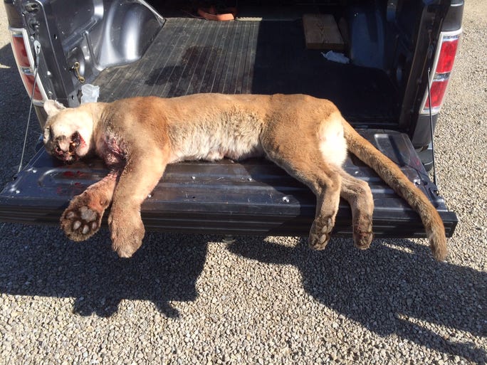
Another Mountain Lion - Laclede County 2015

A mountain lion was euthanized by state police after being struck by a vehicle on I-44 in Laclede county Tuesday May 12th, near the Gasconade River bridge at the 144 mile marker.  The animal was a subadult male (meaning it was not fully grown) weighing approximately 130lbs and untagged. Further investigation shows it was not someone's pet or zoo animal and apparently had a taste for raccoon.
The mountain lion troopers had to euthanize on I-44
Photo Courtesy of Missouri Department of Conservation
Laclede county is due south of Camden county and where the lion was struck is about 50 miles southeast of the Lake of the Ozarks.  It is likely the animal came from the bootheel of the state where sightings are more common, such as in Reynolds county near the National Scenic Riverway. There have been two official sightings in Pulaski county (another neighboring county) in the past 12 years but this is the first documented lion in Laclede county.  It is my conjecture that the lions are using the Gasconade River basin to migrate. The Missouri Department of Conservation still maintains there is no "breeding population" of mountain lions in Missouri but this is the 54th incident since they began documenting them in 1999.

MDC maintains a team of biologists to investigate mountain lion incidences when involving public safety or "substantial physical evidence".  The Mountain Lion Response Team was established to help track activities and observations and evidence can be submitted to"mountain.lion@mdc.mo.gov"